Where to Go Middle Fork of the South Platte
Current Reports
Angler's Covey Bug of the Month
Bug of the month videos here
Visit the blog here
SUMMER HOURS 6am to 6pm Daily
Report Date: 7/5/2025
Current Conditions:
Tomahawk is flowing at 104 cfs. and this is a great time to start targeting that area! Dry or hopper/droppers is the name of the game. Try working the banks and swinging your droppers underneath the banks.
The mosquitos are out and it can get pretty bad here with them. Take bug spray!
Hatches:
We are seeing some mayfly, midge, and caddis activity up here. Terrestrials always do well on the middle fork sections too.
Tactics:
Cover ground. This is a super fun time to take a hopper dropper system and just walk up the river.
Weather:
Short Term- We have seen some pretty typical summer weather and temperatures up here. It has dried out a bit and we are starting to see some higher fire danger up here. This weekend will be warm with temps in the low 80's and very little chances of rain. We will see a similar pattern going into next week as well. We will get extremely warm by mid week and will see temps reach the middle to upper 80's! Even with lower precipitation chances, keep a tab on the skies as storms can come in suddenly. Summer time is here and its certainly going to feel like it!
Long Term- As we roll through next week, we will see increased chances of precipitation towards the end of next week. Temps will cool off a bit and rain chances increase to around 60%. One thing to keep in mind is that any storms we usually see in the summer are very brief. Oftentimes it clears up right after a rainstorm. Longer range forecasts are predicting a hotter and dry back half of the summer. These forecasts are not a sure thing, but it can help paint an overall picture of our weather patterns.
RECOMMENDED PATTERNS
For a custom fly assortment for this location, click here!
Our Top 6 Nymphs for Today:
- Spanish bullet, size 16-18
- 2 bit hooker, red, sizes 16-18
- Foamback emerger, brown, size 20
- Beadhead hares ear, sizes 16-18
- Warrior perdigon, sizes 16-18
- Beadhead soft hackle pheasant tail, size 18
Our Top Dry Flies for Today:
- Mole Fly, natural. Size 18-22
- Stubby chubby, any color, sizes 14-16
- Elk Hair caddis, sizes 16-18
- TL hopper, royal, size 14-16
- Chubby, royal, size 14-16
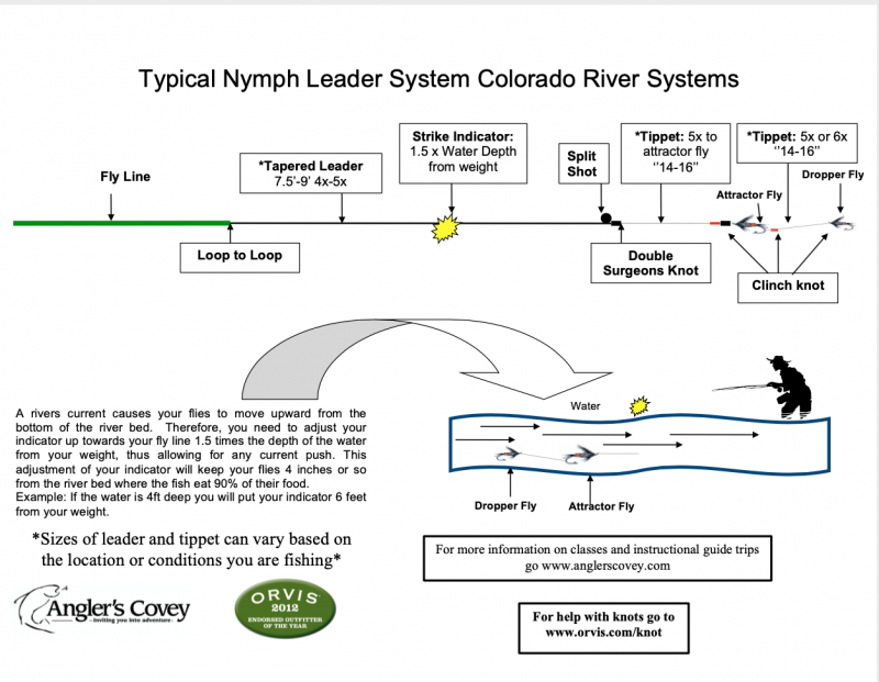
Standard nymph rig set up for the South Platte:

Screenshot the diagram above to reference while you're out on the water!
BE SURE TO CHECK OUT OUR "WHERE TO GO" PAGE FOR DETAILED INFORMATION ON OTHER AREAS!
About Alma SWA
Middle Fork of the South Platte River finds its headwaters above Hoosier Pass. Water is diverted from the Breckenridge area and passed through a tunnel under Hoosier Pass into Montgomery Reservoir. This augments the flow particularly in the early summer.
About Tomahawk
Tomahawk is the Middle Fork of the South Platte River. This stretch of the river is a great place to find solitude from the crowds. Summer and fall are a great time of the year to throw big hoppers to eager brown trout. In the summer, bring insect repellent because the mosquitos can get bad. In the fall, bring heavy leaders because large browns come out of their typical hiding spaces and move up river from Spinney to spawn.
This is an area we specialize and are permitted to guide, so give us a shout if you have any questions or if you are interested in allowing one of our Orvis-Endorsed guides show you how best to conquer Middle Fork of the South Platte.
Interested in Booking a Trip?
Directions to Alma - 88.9 miles - 1 Hour 42 Minutes
- From Angler's Covey head west on US 24 W/Cimarron St, go 63.2 miles
- Turn right at CO-9 N towards Fairplay, go 16.1 miles
- Turn right at US-285 N, go 1.0 mile
- Turn left at CO-9 N/ Main Street, Fairplay and through Alma, 8.1 miles
- Watch your speed, this area is famous for speed tickets.
- Turn left at Co Rd 4, Park along stream in desinated areas.
Directions to Tomahawk - 70.5 miles - 1 Hour 19 Minutes
- Head West on US-24, go 63.2 miles
- Turn right on Co-9, go 7.2 miles

