Geeking Out on Colorado’s Snowpack
Guest Blogger, Jon Easdon (Our Director of Services) writes: I have to admit, I’m a bit of a geek with snowpack. Maybe it comes from my days in the snowboard industry when I became accustomed to watching snowpack info like a hawk. It was a way for me to loosely measure how successful business might be. I kept a keen eye on snow conditions and watching the snowpack was an important part of that.
Well, not much has changed these days.
As an angler, watching our snowpack is equally important for many different reasons. Over the last decade, much of the west has been inundated with severe drought conditions. We have all seen what one bad winter can do in terms of drought damage. Conversely, a few good storms will start chipping away at the drought. Snowpack will measure how much water we will have throughout the spring, summer, and fall. This can also give us a good idea on our wildfire danger for the year.
Water affects not only river flows, but insect hatches, fishable rivers and streams, and gives us a snapshot on what our reservoirs and tailwaters might be like over the coming months. In simple terms, snowpack in our late winter months can give us an idea of how good this coming year will be.
In the following graphs, the term “snow water equivalent” is repeatedly used. Simply stated, “snow water equivalent” is the depth of water that would cover the ground if the snow cover was in a liquid state.
The Western States
It’s important to consider the precipitation across the entire western part of the U.S. – not just our local waters. We’re all connected. We have seen some very decent precipitation this year all across the west, and its definitely making a difference.
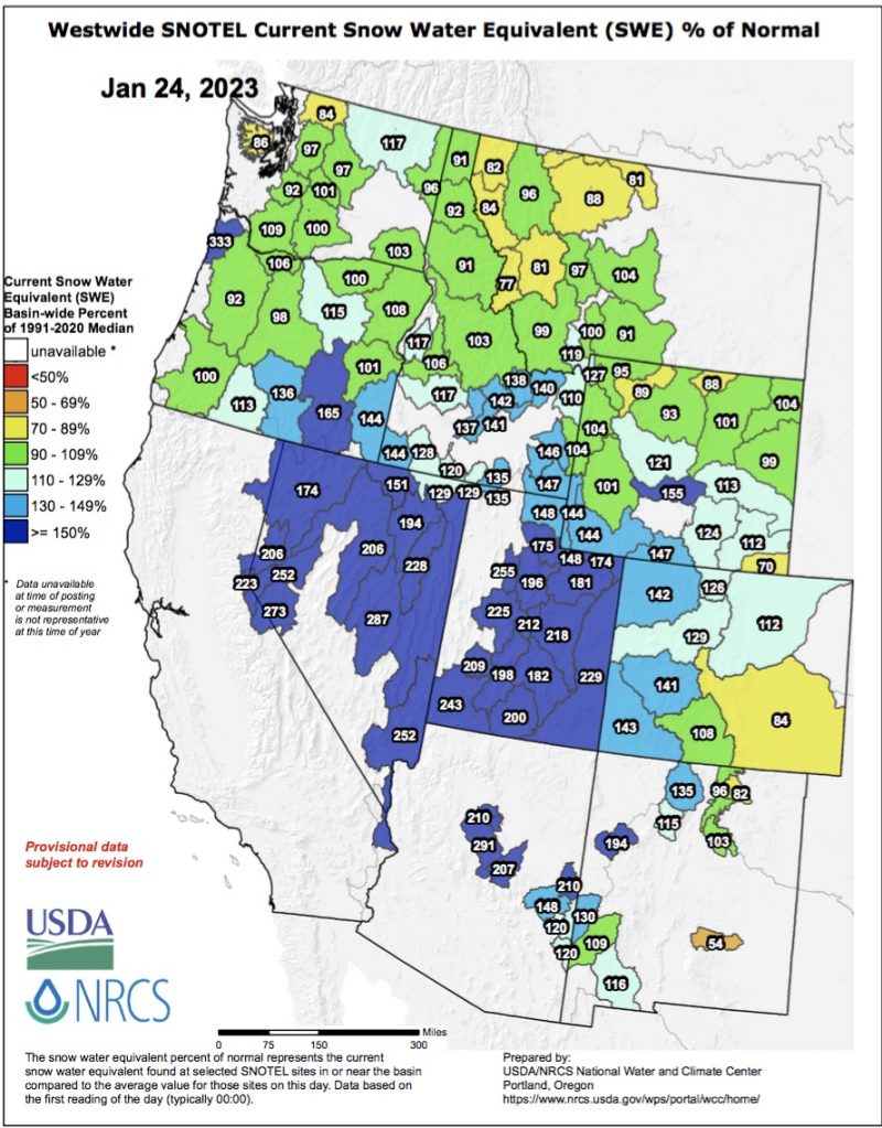
As you can see in this graph, the northwestern parts of the country are sitting right about average snowpack. This is very typical in a La Nina weather pattern. The thing to look forward to is that the weather pattern has the potential to bring some big storms in the spring.
This snapshot of the entire west and its snowpack shows parts of Utah, Nevada, and even California. There is also well above average snowpack in every basin south of Utah and Colorado. Look at those numbers in Arizona!!
Colorado Snowpack
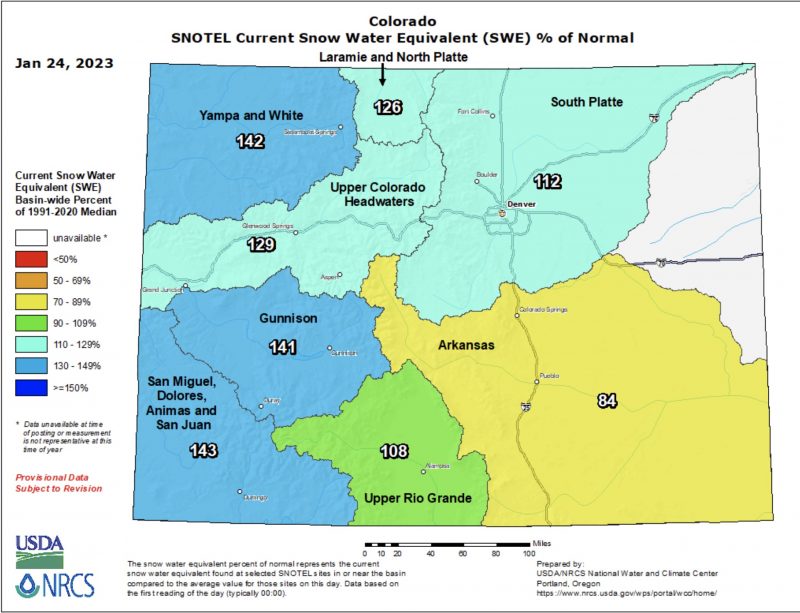
In Colorado in late January, we are currently sitting with a pretty good snowpack.
The Colorado River Headwaters
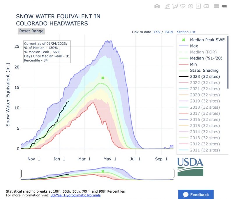
We are seeing some really good reports in areas that have been low the last few years, particularly the Colorado River basin. This area has been ravaged with low snowpack and severely increased water demand. The water levels in the Colorado River have been so bad that there have been fears that Lake Mead could no longer support hydro power, which supplies a large portion of the western US with power. While it will take years of positive snowpack to mitigate this, 2023 is off to a good start.
The Southwest Region
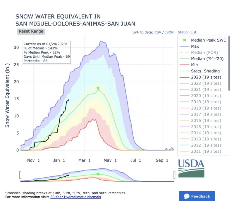
The regions in the southern part of the state are also off to a great start.
Last winter we saw our southern basins report good snowpack. The folly of last year is that temperatures warmed up too quickly in the spring. Runoff started and ended early. Our snowpack was lost in a very short period of time. We are on a similar pace this year and the numbers look good down south. The San Miguel, San Juan, and Upper Rio Grande basins are some of the highest in the state right now. Lets hope that it can last a little longer this spring.
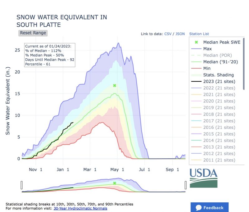
The South Platte
Locally in the South Platte basin, we are seeing just above average snowpack. It’s good to remember, though, our best months for precipitation are March and April.
The Outlook
Winter snowpack data is especially important for forecasting water conditions in the spring and the summer. In the winter we have a very low sun angle and shorter days. The snow does not really melt this time of year. These are great numbers to build on and almost all of the snowpack we have now will last into spring.
Here in Colorado, December and January are historically low months for gaining snowpack. That certainly wasn’t the case this year and we enjoyed some large and sustained early season storms. In Colorado and much of the west, our largest precipitation months are March and April. As we have seen in the past, it only takes one or two big storms to really ramp up these numbers.
The key this year will be a slow warm up into spring. If this happens our snowpack will really get stretched out heading into summer. As we have seen in the past, when temperatures get too warm too fast, we can lose the snowpack at a rapid pace. Not only are our fisheries impacted, this quick melt also greatly increases our wildfire danger.
We will be intently watching the weather and the snowpack as we head into spring. If things stay on the current track, we should be looking pretty positive in terms of water this year all across the west. Check out our up-to-date fishing reports real-time river flow information.
Keep doing those snow dances — they appear to be working.

Love geeking out on this stuff! Great stuff Jon, the more I know about all things that affect our fisheries, the better Angler I become.
Jon, we spell our first names differently. But, we have the same passion for snow pack in the mountains! It was so great reading your story in one concise spot. I’ve been following the snow pack for a long time and realizing how important it is for the skiing industry, for forest health, for fishing, all summer!! I even canceled a trip couple of summers ago to Southwest Colorado, because the water wasn’t flowing good enough!! We have the same passion. It was so good to see that map of the western United States with Arizona and Utah, and all those numbers! You have helped me so much when I’ve come in to the shop and this article does the same ! Beautiful stuff Jon!!